
WINTRY MIX: After some overnight rain showers, we’re rain free for a bit today. A few showers are possible early in the day here and there; however, most of the midday and afternoon should be dry. Highs today will be held in the upper 30s to near 40° with a blanket of clouds staying in place.
A ripple of energy rides along a stationary front to our south this evening. This will shove moisture northward into PA. We expect rain to begin in the evening hours. Some spots will see some sleet mix in south of the PA turnpike. To the north, snow flake may mix in early. Then overnight, the story looks a bit different depending on where you live. The rain or snow will end by midday Wednesday. Lows tonight will be near freezing.
The area south of the turnpike and east of I-81 should remain mostly rain with some sleet mixing in. Accumulations look limited.
North of the turnpike, rain will switch to snow in the late evening and overnight hours. Accumulations look low with 1-2” for most. Areas to the far north like Snyder & Northumberland along with higher elevations in Mifflin, Juniata, and Perry counties can see 2-3” of snow.
Also, there’s a small chance for some freezing rain, especially in Franklin/Adams/Cumberland counties as temps may fall to freezing near the surface before the rain switches to snow. A glaze of ice is possible on objects, but it’s unlikely on roadways at this time.

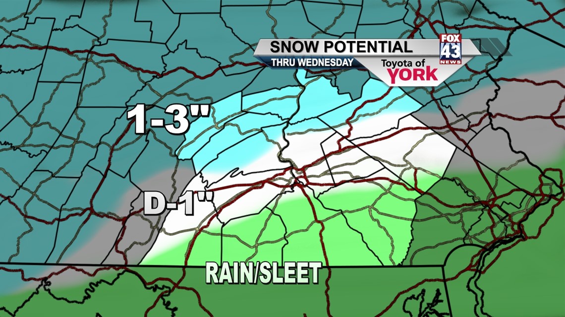
A Winter Weather Advisory is in effect for all but York and Lancaster counties.
LATE WEEK CHILL: We begin clearing Wednesday afternoon as a pocket of colder air slips in form our north. Highs to close out the week will be in the mid to upper 30s. Lows are in the 20s. We will get to see more sunshine though!
WEEKEND: The weekend looks nice and quiet. Saturday will be mostly sunny with a bit of milder air nudging northward into PA. Highs will be in the mid 40s. Sunday, a pocket of colder air slips in with highs only in the upper 30s. Low pressure to our north will add clouds to the area.
MUCH COLDER: It looks like the really cold air from Canada makes an appearance next week. Monday, we’re only going to hit 30° and the cold air looks to linger into the early part of the week!
Have a terrific Tuesday and safe travels tonight and tomorrow.
– Jeff Jumper, Fox43 Morning Meteorologist
Follow me on Twitter: @JeffJumperWX
Like me on Facebook: Jeff Jumper Fox43