
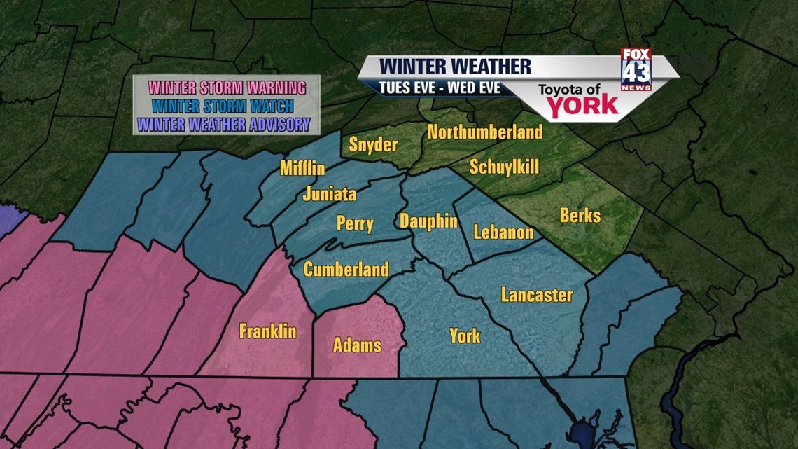
…A WINTER STORM WARNING IS IN EFFECT FOR FRANKLIN AND ADAMS COUNTIES FROM 6PM TODAY UNTIL 6PM WEDNESDAY…
…A WINTER STORM WATCH IS IN EFFECT FOR A MAJORITY OF OUR VIEWING AREA FROM 6PM TODAY UNTIL 6PM WEDNESDAY…

TUESDAY CALM: Our best shot at winter weather this season is coming tonight into Wednesday. As we await the approach, we’re still tackling some of the minor details on storm specifics. However, the hours leading up to the first flakes look rather tranquil. We start with sunshine and end with clouds rolling in later today. Highs for your Tuesday will be in the low to middle 40s.
WEDNESDAY STORM: The picture is becoming clearer by the hour as to what we’re expecting with Wednesday’s storm. The one note I’d like to make: expect a few surprises. This storm system has been tough to model, but finally we’re getting into some broad agreement. Here are some of the major points…
- TIMING: The first flakes will fly to the west later this evening. Snow will then spread from the southwest to the east during the overnight hours. Snow continues through Wednesday morning into the midday and afternoon hours. Snow tapers on Wednesday evening. Heaviest snow looks to arrive between 4AM-NOON, give or take an hour or two.
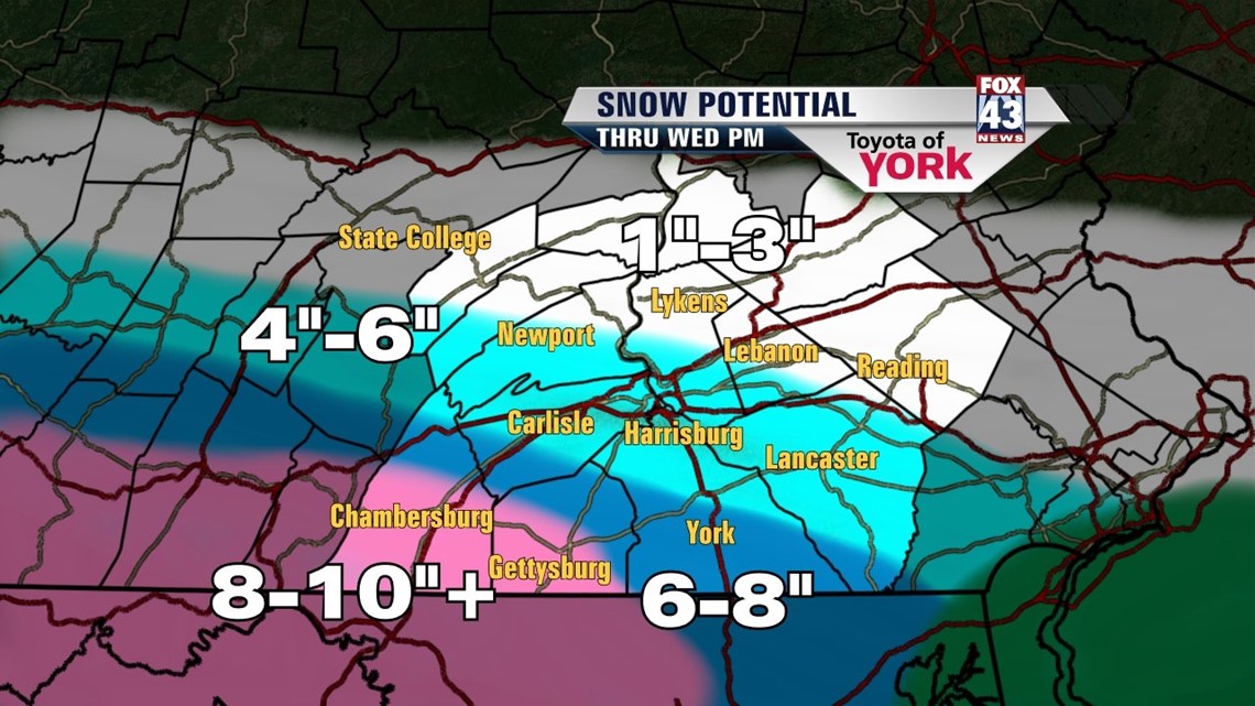
- ACCUMS: Refer to the map below as a basic guide for your area. However, the models paint a clear trend of a heavy “bull’s eye” of snow just to our west and south. The trends continue to show the snow dropping off pretty quickly to the north and east of this “bull’s eye”. Best snowfall surprise potential will be counties hugging the PA/MD border.
- ISSUES: The snow will be heavy at times, reducing visibility and quickly deteriorating conditions on local roadways. Winds will get gusty during the morning and midday, 15-25mph with higher gusts. Give yourself some extra time when traveling.
- CONTACT US: Please send us photos, conditions, and totals via twitter using #Fox43 or to any of our Fox43 Facebook pages, as long as you can do this safely. Your reports help us get information out to others and the National Weather Service as well.

BEYOND: The storm is slow to move away on Thursday, but the precip should end by Wednesday night. We expect clouds to linger and temps to hold in the low 40s. By Friday, we begin to scour the clouds late and the warming trend ensues. We hit the middle 40s for highs.
Saturday and Sunday, we’ll be in the 50s. More sun is in play Saturday with clouds around Sunday. Rain arrives for Monday.
Thanks for trusting us with your forecasts. We’ll likely have some tweaks to make along the way, so stay tuned. Have a great Tuesday.
– Jeff Jumper, Fox43 Morning Meteorologist
Follow me on Twitter: @JeffJumperWX
Like me on Facebook: Jeff Jumper Fox43