

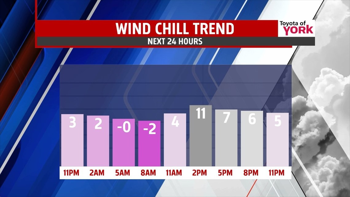
FRIGID AIR LINGERS

Scattered snow showers and flurries continue across parts of the area this afternoon, but through the evening the flurries taper. The clouds break apart too, leaving a mostly clear overnight period. A reinforcement of cold air enters the picture, with lows tumbling into the single digits once again. The breezes taper a tad, so wind chill values feel below 0 degrees at times. Plenty of sunshine is expected for Friday, but it’s still a frigid day. Highs reach the teens to lower 20s. With the breezes continuing, wind chill values are in the teens, and even single digits. Some clouds begin to build late in the day.
WEEKEND CLIPPERS
Clouds quickly thicken Friday night as another clipper system approaches. Snow showers are possible late Friday night, with lows not nearly as frigid in the teens. Light snow is likely on Saturday, with minor accumulations possible. Some spots could pick up a bit more where there are some heavier snow squalls. We get a break for most of Sunday, but yet another clipper crosses Sunday night into early Monday morning, renewing the light snow chance. Highs are in the 20s through the weekend.
YET ANOTHER ARCTIC BLAST
Monday skies clear a bit into the afternoon hours, but another arctic air mass is coming! By Tuesday morning, the chill settles in, with lows possibly near 0 degrees! Afternoon highs are in the teens. The brutally cold air sticks around through Wednesday. We’ll have to wait until Thursday for some moderation to take place, but even then highs are still below seasonable averages in the 20s!
Have a great night!
-Andrea Michaels