
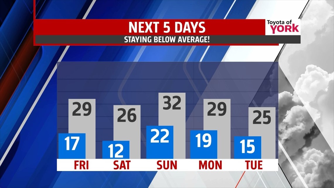
OVERVIEW: A large area of high pressure spreads in across the area, keeping us dry and quiet. An area of low pressure will move out of the mid-west Saturday and may spread in a quick period of light snow but nothing more. Then another piece of energy on Sunday will produce another shot of light snow, again, shouldn’t be a big deal. Colder air hits the area as we head much below normal early next week.
TONIGHT: Mostly clear skies right now will continue into the evening and overnight. We may see a few more clouds drift in from time to time creating partly cloudy skies but the clouds are expected to thin out during the morning hours. With light winds and very minimal cloud cover, along with current snow pack, lows will get very cold, dropping to the middle and upper teens.


WEEKEND OUTLOOK: Most of Saturday you can expect lots of clouds and dry hours but there will be a quick shot of light snow as a system comes in from the mid-west. Highs remain in the middle to upper 20s, well below average. Another strong piece of energy for Sunday will swing through and again we may deal with some light snow showers. Together with both systems, they only look to produce nothing more than an inch of snow or less as of now. Temperatures will be a bit better warmer in the low 30s.

OUR NEXT STORM: We are watching the next storm which models are depicting arrives Wednesday into Thursday. Still too many days out to comment much more than we could see some snow and we’ll watch it closely, keeping you up to date of any changes.
MaryEllen Pann, Chief Meteorologist
Like me on Facebook: maryellenpannfox43
Follow me on Twitter: @MaryEllenFox43