

WARMING UP


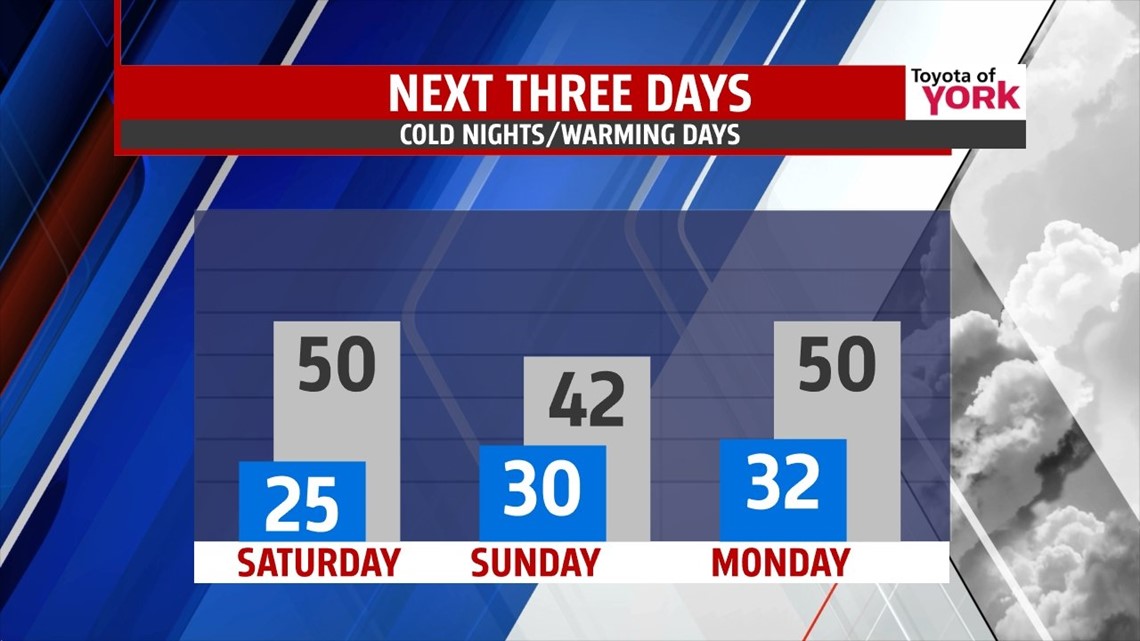
A coastal storm just off shore is bringing clouds across the region this afternoon, particularly along the eastern parts of our area. There’s more sunshine to the north and west. As the storm pulls away from the coast, the clouds fade from west to east this evening. Overnight lows fall into the 20s again under partly cloudy skies. An approaching cold front quickly brings back clouds Saturday morning. Skies are dry Saturday, but a few sprinkles and flurries are possible overnight into early Sunday morning. Otherwise, Sunday is dry with a plenty of sunshine. Highs are in the middle to upper 40s Saturday, and fall a few degrees for Sunday. Don’t forget, Daylight Saving Time begins Sunday morning! Push those clocks forward an hour before bed on Saturday night. It’s also a great time to change the batteries in your smoke detectors and carbon monoxide alarm.
MORE MILD DAYS
Conditions stay quiet into the beginning of next week, with temperatures continuing to rise. It’s fairly cloudy both Monday and Tuesday with a warm front draped just to our north. That shouldn’t prevent temperatures from being near 50 degrees on Monday and rising into the middle 50s on Tuesday!
NEXT STORM SYSTEM
Our next storm system comes this way Wednesday, brining rain showers with temperatures still mild to start. Cold air rushes in behind the system late Wednesday into early Thursday, so it’s possible we could see some snow on the backside of the storm as it lifts away. Either way, it’s return back to the cold that lasts through Friday.
Have a great weekend!
-Andrea Michaels