

JUNE ARRIVES:
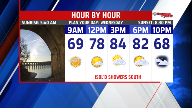
Morning clouds and haze on Wednesday will burn off leaving mostly sunny skies. However, clouds build during the afternoon, and an isolated shower can’t be ruled out, especially along our southern counties. Temperatures are still warm in the lower 80s. Winds pick up out of the east-southeast allowing more moisture to stream in bringing more clouds and causing the humidity to inch upward. Mostly cloudy and mainly dry for Thursday, however, showers will arrive towards the late evening and continue into Friday ahead of our next system. Highs are near 80 degrees but fall back to the upper 70s for Friday with showers and thunderstorms expected much of the day.

WEEKEND OUTLOOK:
We are dry behind the departing front for Saturday with partly cloudy skies. Highs sneak into the upper 70s to lower 80s. Our next system quickly swings in for the second half of the weekend bringing threat for showers and a few thunderstorms. Highs are held in the middle to upper 70s.
NEXT WEEK:
The first full week of June brings arrives with lingering showers on Monday, and near seasonal temperatures in the middle to upper 70s.
2016 HURRICANE SEASON:
The hurricane season officially begins June 1st. We have already had two tropical cyclones, Alex and Bonnie, both forming before the season started. NOAA’s outlook is for a near average number of tropical systems to form. Here is a breakdown of their forecast.


Stay with FOX43 Weather for updated changes to the forecast through the rest of the week!
Have a good day!
MaryEllen Pann,
Chief Meteorologist
