
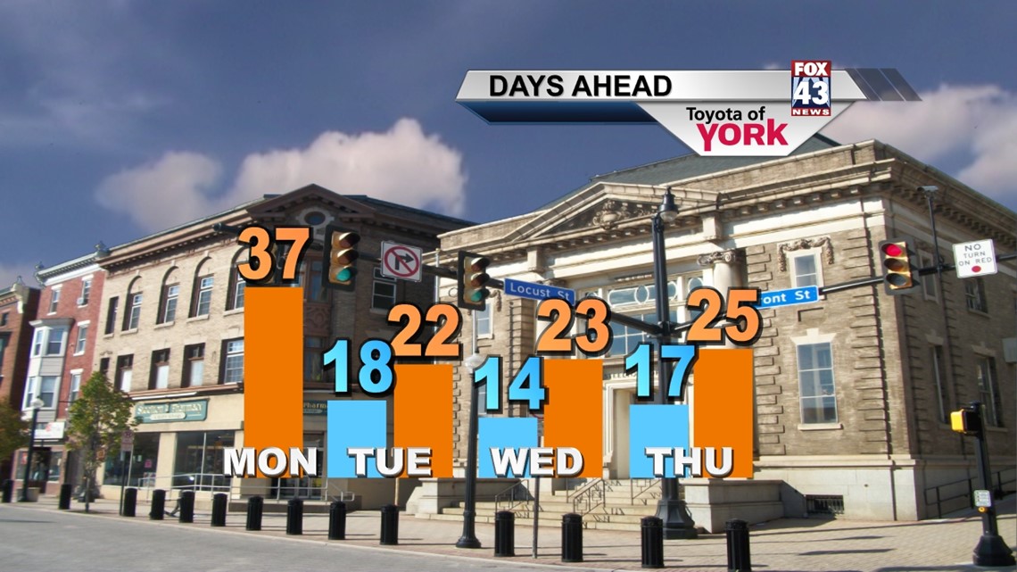
QUICK FRONT: Happy Monday! I hope you enjoyed the 50s this weekend, because they will become a distant memory this week. The arctic invasion is only a few hours away, and it looks like after today we’ll only manage 20s for highs in the days ahead.
A quick front drops south today. With the strong northwesterly flow aloft and added energy from the frontal system, moisture from the Great Lakes will move into the atmosphere and bring clouds today along with the chance for snow showers later in the day. Highs today will hit the mid to upper 30s as flow briefly shifts southwesterly during the morning. Then the front approaches bringing snow showers into the late afternoon and early evening before tapering. Most of us will see less than an inch, if that. A few spots in our higher elevations may pick up an inch or so.
Winds shift to the Northwest at 10-20mph, gusting to near 30mph this evening. This will shove arctic air into the Mid-state for the rest of the week. Tonight, we bottom out in the upper teens with wind chills in the single digits! Dress warmly!
ARCTIC LIFE: The frigid air is with us through late week. We’re talking teens for lows and 20s for highs for several days. It’s windy and very cold Tuesday with limited sunshine. Some sun will come out Wednesday but again we’re in the low 20s for highs. Winds will finally relax Wednesday as the core of high pressure slides past us. Thursday, the clouds are back as a system dies as it moves toward PA from our north.

FRIDAY SNOW CHANCE: A fast moving, quickly developing system moves in from the south overnight Thursday into Friday. Right now, models are differing on timing and strength, but it looks like we will see accumulating snow out of this one. The system looks to move in and out within 24 hours. It’s too early to tell how much snow we’ll get from this one, but do expect snow showers on Friday.
WEEKEND: Friday’s system will help to reinforce the cold air in place for Saturday with highs once again in the middle 20s. We should see a warming trend begin Sunday as we move back into the 30s with extra sunshine in play.
Have a marvelous Monday and stay warm!
– Jeff Jumper, Fox43 Morning Meteorologist
Follow me on Twitter: @JeffJumperWX
Like me on Facebook: Jeff Jumper Fox43