

NICE WEEKEND CONTINUES
High pressure to our northeast is still in control of our weather, and it will keep conditions quiet through the rest of the weekend. Tonight, expect partly cloudy skies with lows in the upper 40s to lower 50s. Light southeasterly winds could keep the atmosphere moist enough for some foggy spots to form once again as temperatures tumble. Not everyone sees the fog however, and it quickly burns off during the morning. A mixture of sunshine and clouds is in store for Sunday. Highs reach the lower 70s again.
MAINLY DRY & WARMING

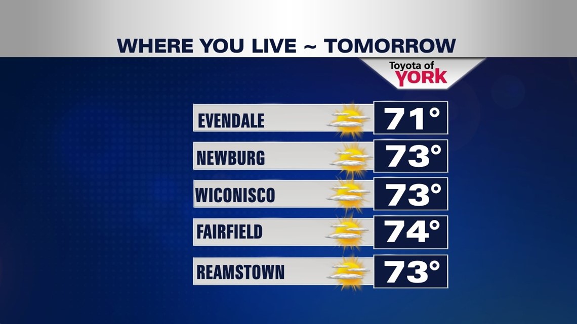
A cold front from the west approaches Monday, but it will likely go through dry. Clouds increase during the afternoon with highs reaching the lower to middle 70s. A shower or two are possible late in the day through early Tuesday. An area of low pressure developing in the Atlantic could meander far enough west to slow down the front and keep some extra clouds around Tuesday. Either way, it looks mainly dry with highs in the middle 70s. Through Thursday, expect a mixture of clouds and sunshine to stick around. Highs warm even higher above seasonable averages, reaching the middle to upper 70s.
NEXT RAIN CHANCE?
Above average temperatures continue through the end of next week. Friday is mild and rather uneventful, with a mixture of clouds and sunshine. We’ll be closely watching the timing of our next cold front, which will bring along with it some much needed rainfall. There is disagreement over the timing, but it looks to pass through either Saturday or Sunday. Highs hover in the middle to upper 70s until then, and sharply drop after the front passes.
Enjoy the rest of your weekend!
-Andrea Michaels