


… A Flood Warning is in effect until 7:15PM for Franklin, Cumberland, Perry, Dauphin, & Lebanon Counties for areas of flooding already occurring…
… A Flood Warning is in effect until 8PM for Adams, York, & Lancaster Counties for areas of flooding already occurring…
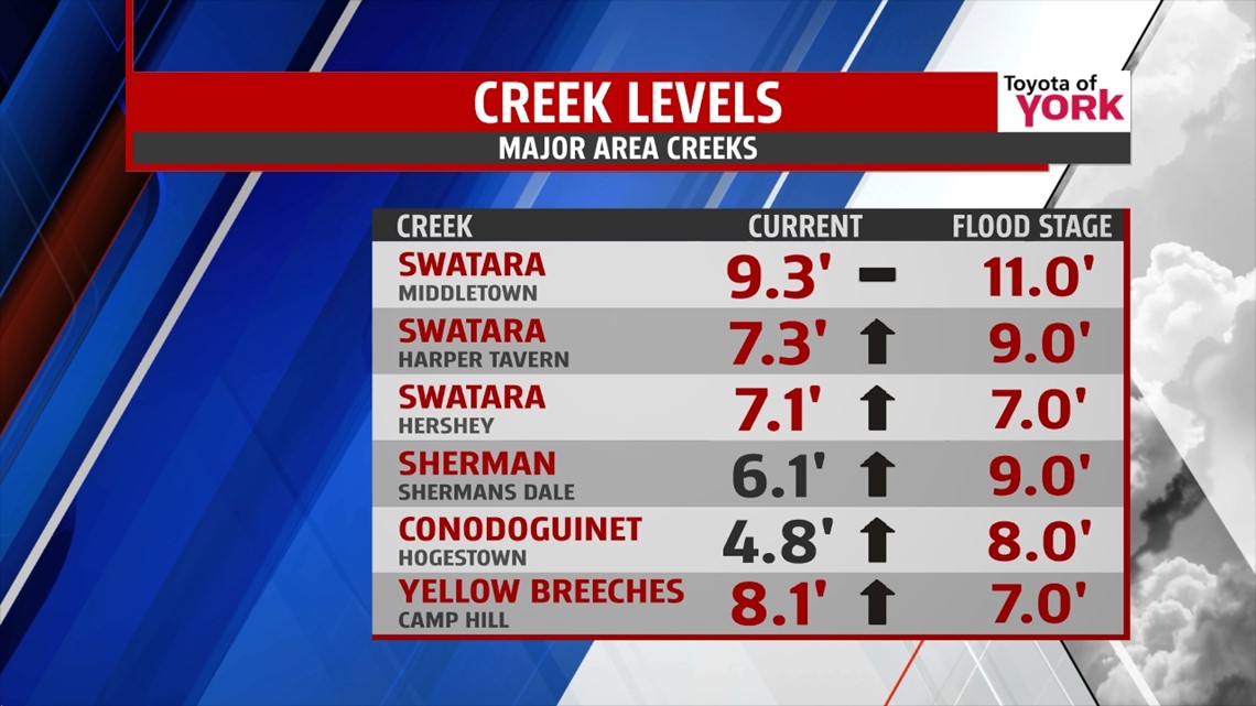
… A Flood Warning is in effect for the YELLOW BREECHES Creek until Sunday morning. As of 2PM, the creek was at 8.4′ and rising. Flood stage is 7.0′ and the creek is expected to crest after midnight at 9.4′ with moderate flooding forecast…
… A Flood Warning is in effect for the SWATARA Creek at Middletown until Saturday afternoon. As of 2PM, the creek was at 9.4′ and steady. Flood stage is 11.0′ and the creek is expected to crest around midnight at 11.6′ with minor flooding forecast…
… A Flood Warning is in effect for the SWATARA Creek at Harper Tavern until Saturday morning. As of 2PM, the creek was at 7.5′ and rising. Flood stage is 9.0′ and the creek is expected to crest Friday evening at 9.5′ with minor flooding forecast…
… A Flood Warning is in effect for the SWATARA Creek at Hershey until Saturday morning. As of 2PM, the creek was at 7.2′ and rising. Flood stage is 7.0′ and the creek is expected to crest Friday evening at 7.5′ with minor flooding forecast…
… A Flood Warning is in effect for the CONODOGUINET Creek at Hogestown from tonight until Sunday morning. As of 2PM, the creek was at 5.3′ and rising. Flood stage is 8.0′ and the creek is expected to crest Saturday morning at 8.5′ with minor flooding forecast…

… A Flood Advisory is in effect until 3:30PM for Mifflin & Juniata Counties for areas of flooding already occurring…


…A Flood Watch continues through 8PM for our area due to the potential of flooding with additional rain today…


MORE RAIN: The coastal low brought us clouds and rain, but the heavy rain was unexpected. Some areas have already received over 4” of rain and more is in the forecast for today. Periods of rain can be expected as we move though our Friday. Showers to heavy downpours will move through, supplied by rich moisture off the Atlantic. Expect several hours of rain again today. We could see an additional 2-3” of rain fall on already saturated ground, so flooding of roads and small creeks and streams remains likely in some locations. Highs today will be held in the low 60s.

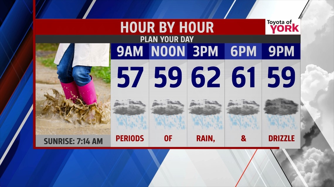
The rain should break up and become less widespread as we move into the evening hours. Bring rain gear and boots to navigate local high school games tonight. Temperatures will be near 60° with cool, damp air in place.
WEEKEND: Saturday and Sunday look cloudy still as this low slowly breaks down and slips away. Saturday, we may see some drizzle or a few showers. Highs hit the mid 60s. Sunday, a peek or two of sun may return, but easterly flow will help keep the clouds and cool air settled in place with highs holding in the mid 60s. A stray drop or two can’t be ruled out.
NEXT WEEK: A weak front make sit near the region on Monday, which will help to start breaking up the clouds. We’re mostly cloudy with highs in the upper 60s. Tuesday will feature more sunshine as we await our next system. Highs hit the low 70s. Wednesday into the end of the week, we’re still hammering out the timing of the next system. For now, Wednesday looks partly cloudy and mainly dry, with rain arriving for Thursday and maybe into Friday. Highs will hold near 70°.
Remember, if you see a flooded roadway, “Turn Around, Don’t Drown”. Please tweet or Facebook us your flooding reports and photos only if you can do it safely.
“Be mindful that happiness is not based on possessions, power or prestige, but on relationships with people you love and respect.” – H. Jackson Brown, Jr.
– Jeff Jumper, WPMT Fox43 Morning Meteorologist
Follow me on Twitter: @JeffJumperWX
Like me on Facebook: Jeff Jumper FOX43