

WINDS TAPER… TEMPORARILY

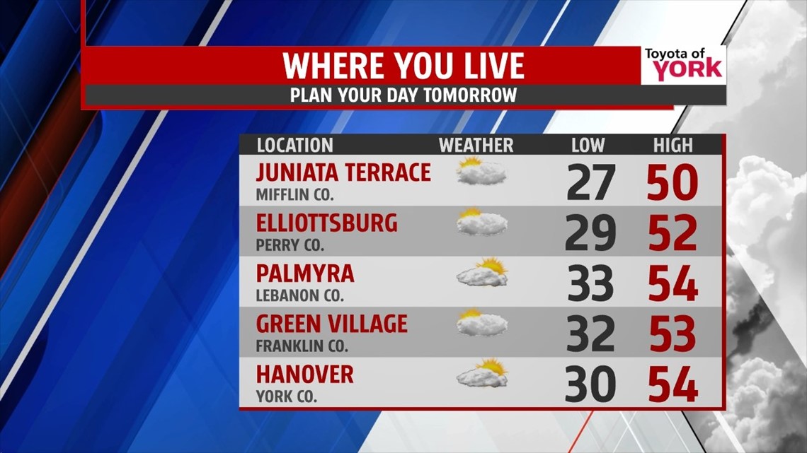
Clouds are hanging tough across the region, but they slowly begin to lift out as the evening progresses. The gusty winds also begin to slowly fade through that timeframe. This allows lows to drop into the upper 20s to lower 30s across the region. All eyes are on a potent cold front approaching from the northwest as we move forward into the new workweek. This begins to increase clouds a bit early Monday morning, but there will still be sunshine as we wake up across the Lower Susquehanna River Valley. The clouds will quickly thicken, however, as the day progresses. Winds become breezy once again, mainly during the afternoon hours. With southwesterly winds in place, highs should reach the lower to middle 50s despite the added clouds. The cold front pushes through overnight Monday, bringing the chance for a few rain, and even snow showers as it gets later. No accumulations are expected.
MIDWEEK COLD BLAST
Behind the cold front, an Arctic air mass pushes into the region Tuesday. The cold air aloft bubbles up clouds in the wake of the cold front. Some lake effect snow showers will likely start up too, and they could clip our northwestern parts. It’s breezy once again, with high temperatures only reaching the upper 30s to lower 40s. Wednesday is another unseasonably cold day, and highs will likely struggle to even touch the 40 degree mark despite more sunshine! Overnight temperatures are quite chilly as well, with lows in the 20s.
GRADUAL WARMING
A southwesterly flow begins to develop Thursday, and this helps to warm temperatures back up through the end of the week. Temperatures warm from the 40s into the lower 50s Thursday into Friday. Skies are sunny as well both days. Clouds begin to build back Saturday with the approach of our next system. Highs are in the middle 50s by then. Our next system increases clouds even more, and brings the chance for showers on Sunday. Highs will push the 60 degree mark.
Have a great week!
-Andrea Michaels