

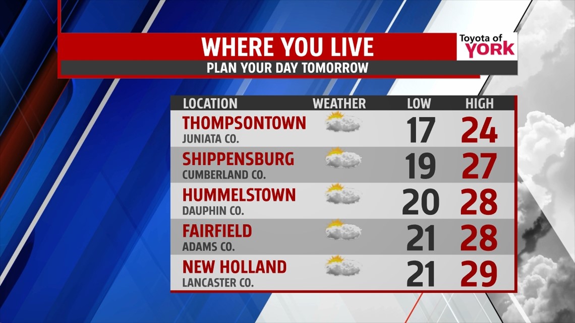
TEMPS STAY BELOW AVERAGE

Clouds are hanging across the Lower Susquehanna Valley this evening, and they’ll be sticking around for some time. A little bit a clearing could work in close to daybreak, especially to the north, but clouds should stick around near the state border. With breezy winds lows likely won’t fall as much as models are projecting, so expect readings in the upper teens to lower 20s. It’s cold nonetheless, and temperatures stay cold for Monday. A weak cold front slides through Monday, keeping the clouds around and reinforcing colder air. The breezes die down during the afternoon. Highs are only in the 20s. Late Monday night into Tuesday, a weak clipper system passes across the area, bringing some light snow showers. By mid afternoon, it should be out of here. Minor snow accumulations are possible, with most areas seeing up to an inch at best. A few locations could see up to 2 inches. Highs are near the freezing mark or a bit below.
WARMING UP
Wednesday skies clear out, and temperatures begin an upward trend. Highs are still below average, with reading in the middle 30s. A southwesterly flow kicks in Thursday, and this warms temperatures closer to seasonable averages. Highs are near 40 degrees. Friday is still a seasonably mild day, with highs in the lower to middle 40s. There is a chance for some showers as our next cold front approaches.
UNSETTLED WEEKEND
The cold front looks to hang across the region through weekend, keeping the shower chance alive. Temps more or less hover at or just below seasonable averages. Bring the umbrella for any remaining holiday shopping adventures!
Have a great week!
-Andrea Michaels