
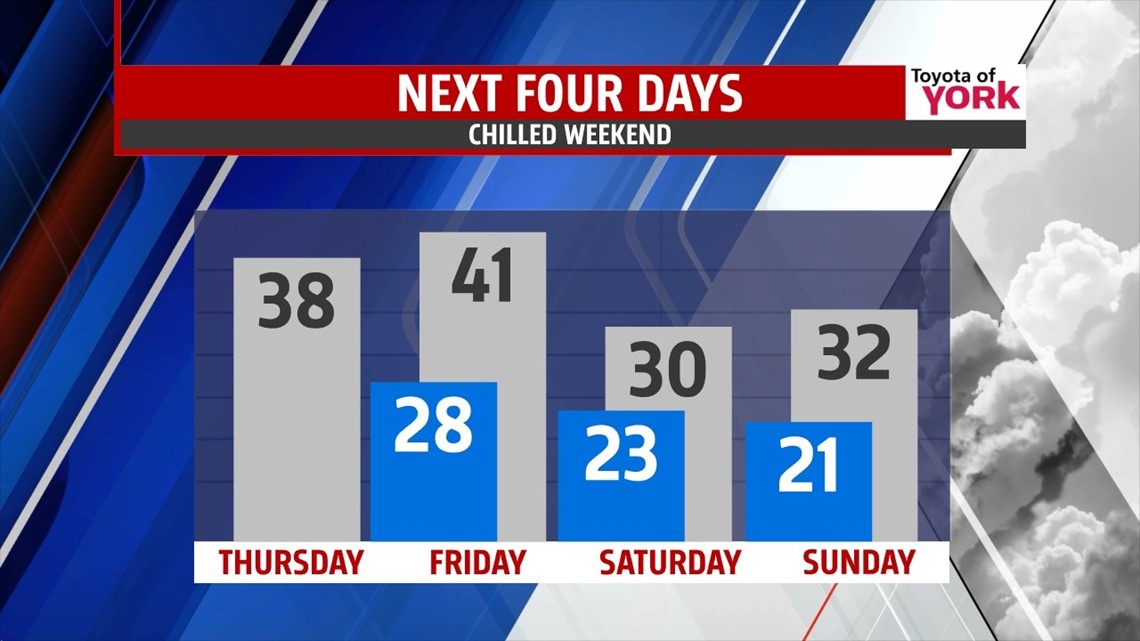
SUNNY CHILL: The morning begins with clouds and some early morning flakes. Watch for a handful of slick spots as you make the commute. By afternoon, skies clear for sunshine. Highs today should reach the upper 30s to near 40° across the region on a quiet day. Overnight tonight, clouds will fill right back in as temps drop to the upper 20s.


FRIDAY: We’ll make a run at the low 40s under mostly cloudy skies. A few light rain showers may develop in the afternoon, but then we expect scattered light snow showers after dark, lasting into the overnight as a fast moving weak system races overhead. Snow accumulation looks limited at this time. Most of it is done by daybreak Saturday.
WEEKEND: Saturday, some colder air fills in. Temps will be held in the low 30s for highs under partly to mostly cloudy skies. We may see another brief shot at some light snow overnight into early Sunday. Sunday looks mainly cloudy with highs in the low to mid 30s. We’re breezy through the weekend.

STAYS ACTIVE: The setup of the jet stream will continue to allow these fast moving waves to ride through, bringing us clouds and brief shots at snow showers. Next week begins with temps in the upper 30s on Monday with partly cloudy skies. A colder pocket of air settles south for Tuesday and Wednesday, dropping highs to the low 30s and mid 20s for mid week with clouds and even the shot for some light snow again into Tuesday, with more waves of energy for late week. We’ll be tweaking as we go.
Have a terrific Thursday!
“The person without a purpose is like a ship without a rudder.” – Thomas Carlyle
– Jeff Jumper, WPMT FOX43 Morning Meteorologist
Follow me on Twitter: @JeffJumperWX
Like me on Facebook: Jeff Jumper FOX43