

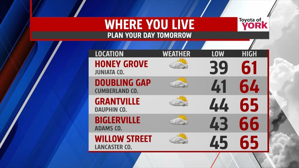
STAYING COOL SUNDAY

Clouds temporarily fade into the evening hours, leading way to a clear and chilly night. Low temperatures fall into the upper 30 to middle 40s across the region. The clouds bubble up again Sunday, and so does the chance for some isolated sprinkles. The best chance will be along the northern parts of our region. Otherwise, it’s a mainly dry and cool day with highs in the lower to middle 60s.
QUIET THROUGH MIDWEEK
The pattern stays quiet overall through the beginning of next week. Monday is mainly dry with more sunshine. There is a chance for an isolated shower or two, but most stay dry. Highs are closer to the 70 degree mark. An approaching warm front increases clouds Tuesday. Highs are a bit milder, rising into the upper 60s to lower 70s. By Wednesday, our next cold front brings the chance for more widely spread showers. Highs are in the upper 60s to lower 70s yet again.
SPOTTY SHOWERS
The end of the week into the beginning of the weekend looks mainly dry, but some small shower chances will try to sneak in. Thursday brings plenty more sunshine with a stray shower possible. Clouds build again Friday courtesy of an upper level disturbance in the atmosphere. A few spotty showers will be possible. Saturday, a mixture of clouds and sunshine is expected. Again, a shower or two will be possible. Highs start in the middle 70s Thursday, and hang around the 70 degree mark Friday and Saturday.
Enjoy the rest of your weekend!
-Andrea Michaels