


Even though we had breaks in the clouds this morning, the thicker clouds plague our skies for most of the day--yet again.
Under those cloudy skies, a few spots will get some sprinkles this afternoon.
Temperatures struggle to get back to 40 this afternoon.
We already hit our high for the day just after midnight. We topped out in the mid 40s.
We get colder air because a cold front came with those showers last night.
As for the showers tonight, we'll keep a careful eye on the temperature.

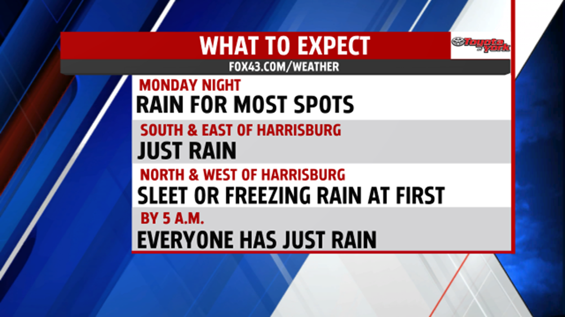
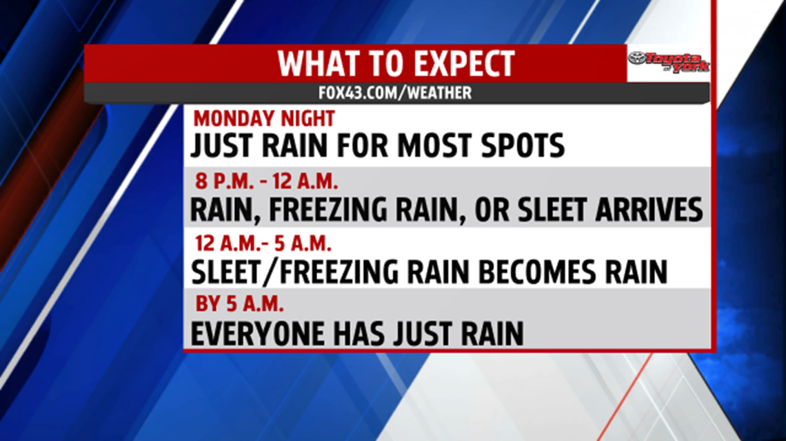
While most of us get just plain rain tonight, spots to the north and west of Harrisburg will see sleet or freezing rain, at first.
So, between 8 P.M. and 12 A.M., steadier showers arrive or steadier sleet and freezing rain arrives depending on where you live.
If you live to the south of Harrisburg, like in Lancaster County, York County, Adams County, southern Dauphin County, and southern Lebanon County, you'll see just rain all night.
If you live in Franklin, Cumberland, Perry, Juniata, Mifflin, northern Dauphin, and northern Lebanon County, you'll get some sleet or freezing rain. As a result, the National Weather Service has your county under a Winter Weather Advisory tonight until 4 A.M.

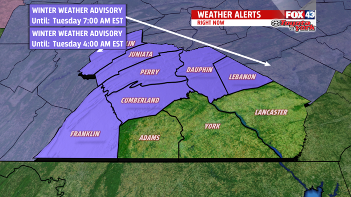
The National Weather Service issued this because freezing rain causes icy conditions on untreated surfaces. To get freezing rain, cold rain hits below-freezing objects on ground and instantly freezes. They also issued the advisory for sleet—frozen raindrops, already pieces of ice when they hit the ground.
Then, between 12 A.M. and 5 A.M., if you live to the north and west of Harrisburg, that sleet or freezing rain turns to plain rain.
This happens because warmer air comes up from the south and spreads north tonight.

The showers wrap up for everyone later Tuesday morning. We'll even see some breaks of sun Tuesday afternoon.
Highs reach the upper 40s on Tuesday.
Then, we fall to the mid 30s Tuesday night as the skies continue to clear.
We start Wednesday with sunshine, but then clouds take over the sky in the afternoon.
In the evening, we'll get a few showers.
The showers continue Wednesday night.
These showers come with another cold front.
On Thursday, we'll get highs in the mid 40 as colder air drops down from the north.
We’ll start out with sun on Friday, but then we’ll turn cloudy in the afternoon. We’ll also have breezy conditions, which will persist for much of the weekend.
Expect highs near 40.
For the first weekend of 2016, cold air continues to march into Central Pennsylvania, so we’ll get more seasonal highs in the 30s.
For scale, we do have average highs in the upper 30s these days.
Look for cloudy skies on Saturday. Then, on Saturday afternoon, we'll even have some lake-effect flurries.

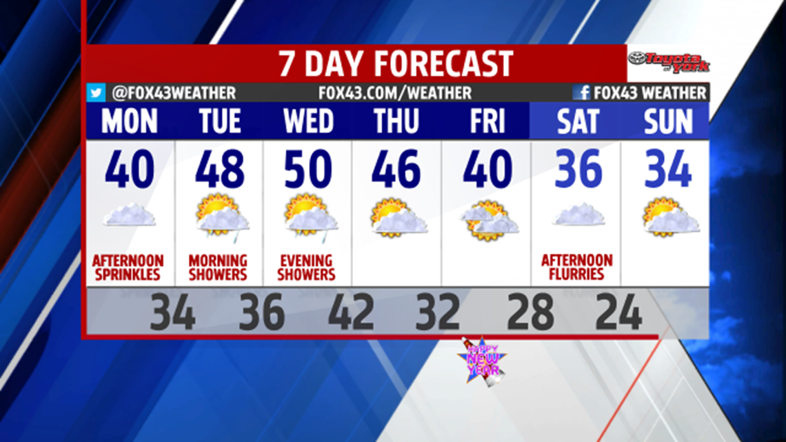
Partly sunny skies return for Sunday and Monday, and highs even go on the rise to near 40 for next Monday.
-Meteorologist Drew Anderson
