

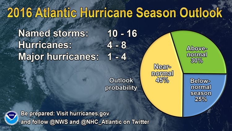
June 1 marks the beginning of the hurricane season in the Atlantic Ocean. Here are three things you need to know about this year’s season:
1) It’s already started! Despite the fact that hurricane season officially starts on June 1 and ends on November 30, tropical systems can form during any month of the year. But conditions are more favorable during the season, when ocean temperatures are warmer and wind shear is lower.
Between December and May there is a much smaller area of warm water to support tropical development and there is also significantly higher wind shear. Wind shear is a weather phenomenon that results in a sudden burst of wind over a short distance. It can occur either horizontally or vertically.
Tropical systems during the month of May aren’t as unusual as you might think. Including 2016, there have been six named storms during the month of May since 2007. This year we had Tropical Storm Bonnie, which brought rip currents and rain during the Memorial Day holiday weekend. Much more uncommon was Hurricane Alex, which moved through the Azores islands in January.
2) El Niño has dominated weather headlines for the past several months, but it is rapidly weakening. In fact, we may head straight into a La Niña pattern by the middle of hurricane season. Why is this significant? El Niño played a large role in the lack of activity during the 2015 hurricane season.
El Niños generally bring increased wind shear over the tropical Atlantic, which deters the development of tropical systems. La Niña is the opposite and typically brings more favorable conditions for the formation of hurricanes.
Does this mean 2016 will be an active year? Possibly. However, the seasonal forecast is quite difficult, as the National Hurricane Center stated last week. How quickly La Niña develops and how strong it becomes will play an important role in this year’s activity. This is also only part of the equation; there are still many factors that have to come together to create an active season.
3) The United States is in the midst of a significant hurricane drought. There were no hurricane landfalls during 2015 and we haven’t seen a major hurricane make landfall in the United States since Wilma in 2005. That’s the longest drought in our reliable period of records, dating back to 1850. In fact, during this decade long drought there have been 69 hurricanes without a landfall by a major storm, one that reaches category 3, 4, or 5. According to NASA, a stretch like this is only likely to happen once in 270 years.
Two of our most hurricane-prone states have gone significant periods without a landfall. Florida’s last landfall was Wilma more than a decade ago, while Texas hasn’t had a hurricane make landfall since 2008’s Ike, a category 2 storm when it hit. Many believe the United States may be due for a major hurricane landfall and it’s important that all coastal residents — from the Gulf Coast to the Northeast — not be complacent.
