

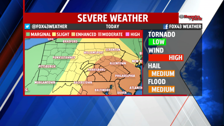


SUNDAY T’STORMS: An approaching cold front Sunday brings widespread showers and thunderstorms. Be alert for strong to severe storms as the system passes. In the morning, we’ll just have spotty showers and a few rumbles. Most of us stay dry. It’s the afternoon we’re watching for severe weather. Expect the threat between 12 P.M. and 7 P.M. The primary threat is damaging winds in excess of 50 to 60 miles per hour with any storms that turn severe. Large hail, an isolated tornado, and heavy downpours that lead to localized flash flooding are also possible. Be prepared to move indoors immediately if you hear thunder or see lightning.
WIND CONCERNS: Some of the thunderstorms are capable of producing wind damage. While it will be a windy day, we’re talking wind gusts over 50 to 60 mph from these thunderstorms. This is the major concern from storms that do turn severe.
FLOODING CONCERNS: Some of these storms could produce flash flooding. There is the potential for some slow moving thunderstorms that produce heavy downpours. We’ll have a better chance for a fast moving line of thunderstorms during the afternoon that dumps very heavy rain in a short amount of time. Flash flooding of small creeks and streams, along with low spots on roads with poor drainage, will be a problem.
TORNADO CONCERNS: The tornado threat is low, but it’s not zero. Model data shows there are some ingredients we look for to get storms spinning. For this reason, an isolated tornado cannot be ruled out. We’ll keep you updated on Sunday’s disruptive weather throughout the weekend right here on FOX43.com.
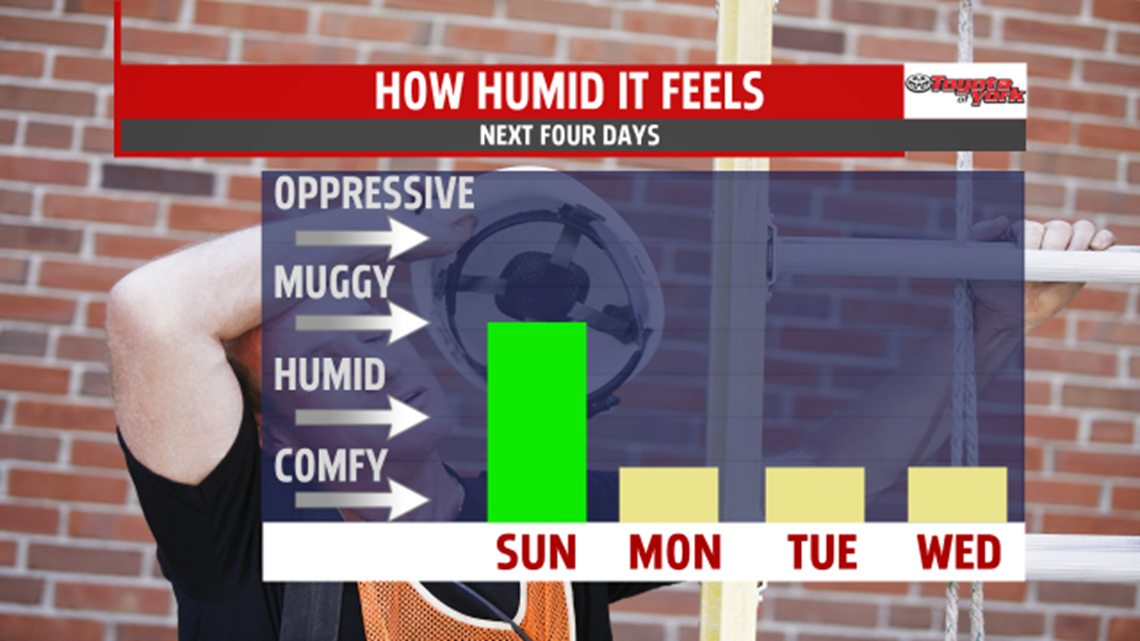
LESS HUMID: After a humid weekend, we finally turn less humid on Monday, and we keep the humidity away for the rest of the week ahead.

SUNNIER SKIES: On Monday, enjoy partly sunny skies. On Tuesday, we’ll have partly sunny skies for the first half of the day. In the afternoon, the clouds will thicken. A few spots will even see an afternoon sprinkle. After low 80s on Monday, we get near 80 Tuesday.
SEVENTIES RETURN: When we get a few of those Tuesday afternoon sprinkles, we also get a cold front. It brings the 70s back for Wednesday and Thursday. We’ll also enjoy mostly sunny skies those days.


NEXT WEEKEND: We get near 80 on Friday with increasing clouds. In the afternoon, we got a shot at showers. The same goes for Saturday morning. The computer models we use to forecast are split on which day we get the rain. So, we’ll be updating the weekend forecast over the next few days. Stay tuned to me, MaryEllen, and Andrea.
-Meteorologist Drew Anderson
