

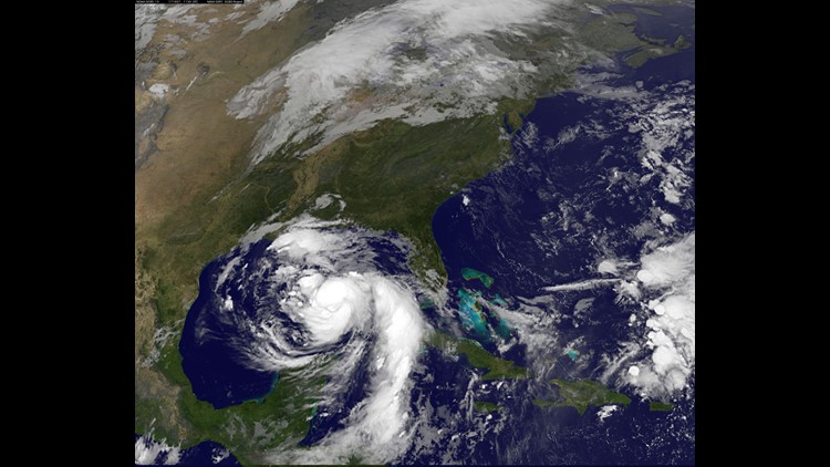
(CNN) — Hurricane Nate was expected to be a Category 2 storm when it makes landfall overnight southeast of New Orleans, the National Hurricane Center said late Saturday morning.
Nate, with lashing winds of 90 miles per hour, sprinted north Saturday morning across the Gulf of Mexico. The Category 1 storm, rumbling north-northwest at 26 mph, was 180 miles from the mouth of the Mississippi River and 265 miles from Biloxi, Mississippi, the hurricane center said in its latest advisory.
“A hurricane warning is in effect for portions of the northern Gulf Coast from Louisiana to Alabama, with the strongest winds expected to occur primarily to the east of the center,” said the hurricane center, which expanded its tropical storm warning east to Indian Pass, on the Florida Panhandle.
“Nate’s fast forward speed after landfall will bring tropical storm-force winds well inland across portions of the southeastern US,” it said.
The storm could make landfall Saturday night around Plaquemines Parish in Louisiana, near where Hurricane Katrina, which devastated New Orleans and the Mississippi Gulf Coast, made landfall in 2005. The storm had been expected to hit some hours later, but predictions were altered as the hurricane sped up.
Some mandatory evacuations had been ordered in areas outside levees in New Orleans and Plaquemines Parish, and some voluntary evacuations were in place along the Mississippi and Alabama coasts. President Trump on Friday declared an emergency in Louisiana ahead of Nate and ordered federal assistance to supplement state and local response efforts.
Strong winds expected
The storm’s reach will be wide, CNN meteorologist Chad Myers said, with strong winds affecting population centers from New Orleans to Panama City, Florida. Biloxi, Mississippi, could experience gusts of 100 mph.
Nate was expected to knock down power lines and trees from Lake Charles, Louisiana, to the Florida Panhandle and possibly leave at least 1 million people without electricity.
“Preparations to protect life and property should be rushed to completion in these areas, as tropical storm conditions will first arrive in the warning area this afternoon,” the hurricane center warned.
Tornadoes may be possible beginning late Saturday afternoon over parts of the central Gulf Coast, the hurricane center said.
Tropical storm watches and warnings were in effect for portions of southeastern Mississippi, Alabama and western Georgia.
Nate could drop 3 to 6 inches of rain, with 10 inches possible in some areas, from the central Gulf Coast north across the Deep South, the eastern Tennessee Valley and the southern Appalachians through Monday, the hurricane center said. Flash flooding is a danger.
“Once it hits land, it looks like it’s going to be very quick to move out of the area and then weaken,” CNN meteorologist Jennifer Varian said.
Hurricane warnings were in effect in New Orleans, including Lake Pontchartrain, and from Grand Isle, Louisiana, east to the Alabama-Florida border. A storm surge warning was in place from Morgan City, Louisiana to the Okaloosa-Walton county line in Florida, and along the northern and western shores of Lake Pontchartrain.
New Orleans braces for impact
Nate would be the third hurricane to hit the US mainland in six weeks. Hurricanes Harvey and Irma tore through some coastal states, killing dozens and destroying thousands of properties.
The storm had already carved a path of devastation in Central America. At least 25 people were killed Thursday in Costa Rica, Nicaragua and Honduras. Hundreds were rescued from floodwaters and mudslides. Many lost power and running water.
New Orleans could experience 6 to 9 feet of storm surge, Mayor Mitch Landrieu said midday Saturday, citing National Weather Service predictions. Storm surge is a gradual rise in the water level caused by a major storm’s wind as it nears shore.
Landrieu already had ordered a mandatory evacuation of the Venetian Isles, Lake Catherine and Irish Bayou areas, which are low-lying or outside the federal hurricane-protection system that underwent a $14 billion overhaul after Katrina. He also had declared a state of emergency.
Anticipating the storm and overnight flooding, Landrieu on Saturday reiterated a mandatory curfew due to start that night at 8 ET and to end when the storm passes. At least 1,800 workers were on standby to reconnect power, if needed, he said.
First responders, sewer workers and residents also prepared for flooding, mindful of summer rains that exposed deficiencies in the city’s unique drainage pumping system.
Of the city’s 120 main drainage pumps, three major and eight smaller ones were offline Friday night, city records show. Also, all 24 major pump stations had backup generators, records show, as only three of five turbines that help power the city’s oldest, most powerful pumps were available for service, a city water utility spokeswoman told CNN.
Gov. John Bel Edwards declared a state of emergency for all of Louisiana and mobilized 1,300 National Guard troops, including some to help monitor New Orleans’ drainage equipment, he said.
“We are … mobilizing all of the state’s emergency preparedness and response mechanisms for a full readiness should this storm severely impact our state,” Edwards said.
Storm surge feared along Gulf Coast
Mississippi Gov. Phil Bryant declared a state of emergency for six counties and any others that might be affected by Nate, the state’s emergency management agency said.
In Biloxi, Mayor Andrew Gilich was especially concerned about storm surge.
“The storm surge is a big thing that really traps everyone,” he told CNN.
Nate could usher in a storm surge of 7 to 11 feet into parts of southeastern Louisiana and along the Mississippi coast, the hurricane center said. That’s far below Katrina’s catastrophic 20-foot surge but still cause for precautions, possibly including evacuations, to be taken in some places.
Gilich said he hopes Nate’s direction and predicted speed “ease the blow.”
In Alabama, the Port of Mobile closed Saturday, meaning the Carnival Fantasy cruise ship would not be “making its scheduled call in Mobile” on Sunday, the Mobile Alabama Cruise Terminal said.
“We recommend passengers stay tuned to communications from Carnival and also check their website for itinerary updates,” the terminal said. CNN reached out to Carnival for details.
The Bankhead Tunnel, a downtown major thoroughfare that passes under the Mobile River, was closed because of Nate, emergency officials and a reporter with CNN affiliate WPMI tweeted.
In Mobile, city workers checked storm drains for debris, took measures to avert power outages and deployed critical equipment.
Across the central Gulf Coast, beaches were ordered to close and some voluntary evacuations were ordered, officials said.
Airports close as Nate nears
Nate’s projected landfall also was having an impact on air travel.
In Alabama, where Gov. Kay Ivey on Friday signed a statewide emergency declaration, the Mobile Regional Airport planned to close Saturday afternoon and reopen Sunday at noon, an airport official said.
In Florida, the Pensacola International Airport planned to cease operations Saturday night and remain closed throughout Sunday, airport officials said.
Meanwhile in Mississippi, the Air Force Reserve’s 403rd Wing relocated its aircraft to Texas and Arkansas.
“We are moving aircraft as a precautionary measure ahead of Tropical Storm Nate, and so we can continue the mission,” said Col. Jennie R. Johnson in a statement.
Kessler Air Force Base in Biloxi was not evacuated, officials said.
