

STRONG STORMS FRIDAY

A quiet evening, and dry too. While it’s dry, flooding concerns remain a serious concern for a good part of the area as on going flooding continues. Skies clear out this evening leading to patchy fog by morning. The ground is plenty saturated, so as temperatures fall close to dew points under mostly clear skies, fog is likely to form and limit visibility for some during the morning drive. Morning lows are in the upper

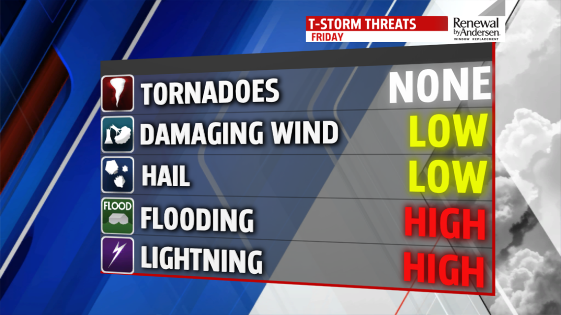
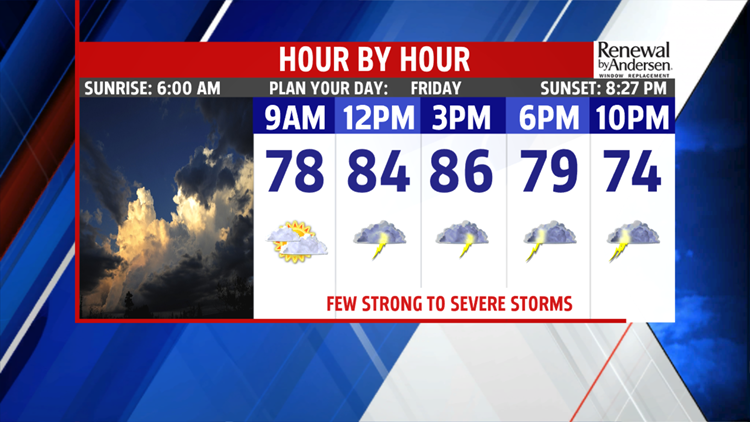
60s to near 70 degrees. Sunshine helps break up the skies which will boosts temperatures into the middle and upper 80s. Clouds begin to increase as a cold front approaches. By afternoon, a few showers and thunderstorms will move into the area. Some of the storms could be strong to severe. Flooding is a significant threat, followed by damaging winds and large hail. Areas currently experiencing flooding and hit hardest by the rainfall, could deal with more flooding should storms roll through. Widespread storms are not expected so not everyone will see them. They will be isolated to a few. High pressure builds in behind the departing system setting up a decent weekend.
WEEKEND OUTLOOK
A much needed dry weekend is expected. Partly to mostly sunny skies Saturday helps to improve conditions on the creeks and rivers. Temperatures are seasonable in the middle 80s. Clouds increase Sunday, however, most of the day is dry. An isolated late day shower or thunderstorm can’t be ruled out. Readings are in the lower 80s.


NEXT WEEK
Heading into the week, the pattern setup is similar to this past week. With that said, it is not as strong but we will still deal with daily showers and thunderstorms beginning late Monday. Highs are in the lower 80s. Tuesday looks like the best shot at widespread showers and thunderstorms. Temperatures are held in the lower 80s. Showers and thunderstorms continue to threaten Wednesday and Thursday with each day seeing less activity. Afternoon readings are a bit warmer in the middle and upper 80s. There is a concern for flooding and we’ll be monitoring the situation very closely.
The FOX43 Weather Team is keeping you “Weather Smart” 7 days a week!
Have a good day!
MaryEllen Pann,
Chief Meteorologist
