


DAMP PATTERN CONTINUES: A cold front is stalling near Central PA, and this contributes to a dreary, drizzly and misty start to the day. Temperatures are a bit milder, and it is muggier, with readings in the 60s. Clouds will linger, but the afternoon forecast is a little more optimistic compared to the last few days despite the stalled front. Some peeks of sunshine are likely, but at the same time, a few showers cannot be ruled out. Even an isolated thunderstorm is possible. It will be warmer, and temperatures reach the middle to upper 70s. The overnight period is dull and dreary. Expect lows in the middle to upper 60s. Some hazy and foggy spots return.
STALLED PATTERN/MORE SHOWER CHANCES: The setup remains stalled through the middle to the end of the week. This means there’s the chance for a couple showers and thunderstorms Wednesday through Friday as the front remains stalled near our region. Wednesday appears to be the best chance for now, with much smaller shower chances through the end of the week. There will be a good amount of dry time for sure, but some isolated heavy downpours cannot be ruled out. This could lead to a few additional areas of flooding, but would at least be very few and far between. Temperatures are warm and stuffy to start Wednesday, with readings in the upper 70s to lower 80s. Temperatures gradually come down a touch each day toward the end of the week. They are in the 70s by Friday. This is due clouds and an east flow setting up as Florence approaches the Carolinas.

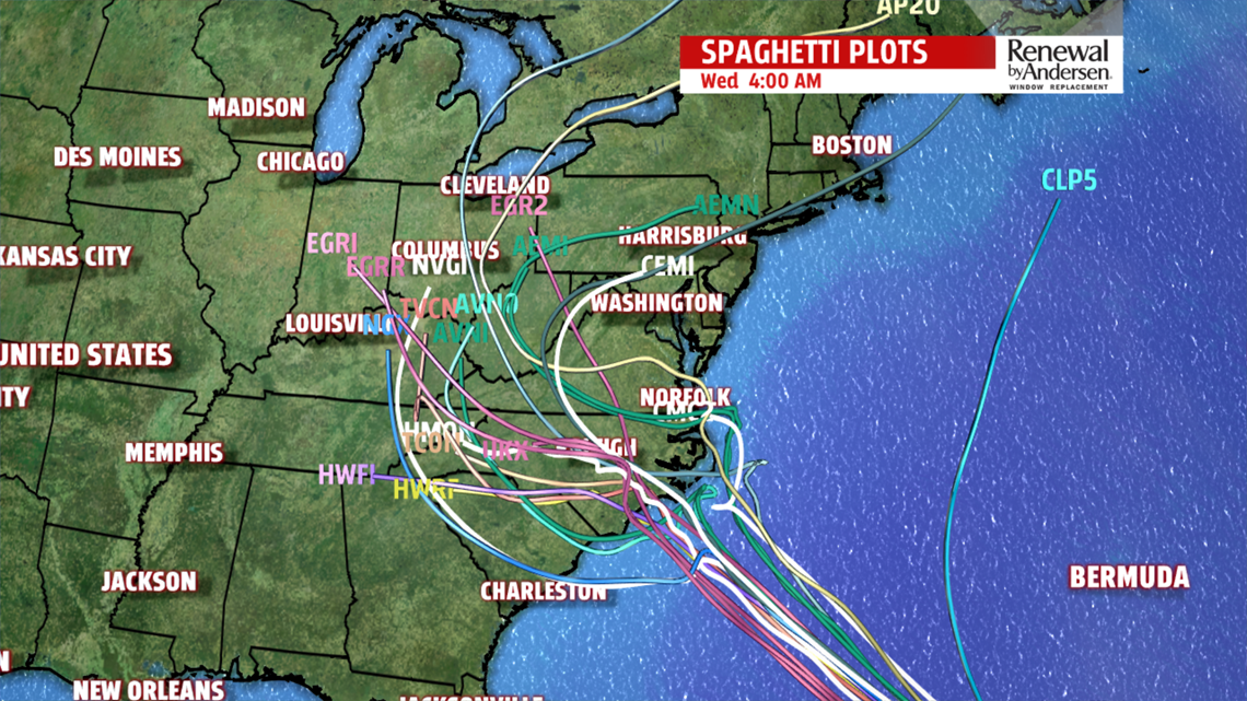
WEEKEND OUTLOOK: A lot of uncertainty continues to revolve around Hurricane Florence as it threatens the US Coast. There is the potential for influence and/or impacts, but a lot remains up in the air at the moment. Models continue to show a new trend for Florence to stall near or inland along one of the Carolinas. Depending on the positioning and the overall track, we could see some amount of moisture influence as it tracks further inland. It is still too early to know with any degree of certainty any of those details, however. The model spread that far out is still all over the place, and positioning ranges over hundreds and hundreds of miles. Of course, with how damp of a summer this has been, any effects would not be good for us and would bring immediate flooding concerns. We’ll continue to watch that potential and keep you up-to-date should it come to that. But for now, we are still in the “wait and see” stages. For now, it looks like Florence and a strong area of high pressure to the northeast helps keep the east flow in place. That means clouds, cooler temperatures in the 70s, a few light showers, and perhaps some drizzly spots. If the remnant moisture were to track more north, of course, more shower or steadier rain activity it likely. Stay tuned and stay Weather Smart!
Have a great Tuesday!
