

DREARY CONTINUES: We continue our muggy, cloudy stretch into the weekend. Temperatures remain in the 70s through the evening under cloudy skies. Stray showers and drizzle remain as well. Morning lows barely dip into the 60s Thursday with morning fog likely once again. Take that into account for your morning commute. Temperatures are sluggish to rise and don’t rise very far. Highs tomorrow stay in the mid-70s. Friday is a near copy, but breezes pick up throughout the day. We stay cloudy with the smallest peak of sunshine possible heading into the weekend.

THIS WEEKEND: We finally dry out just a bit heading into the weekend, as the track of Hurricane Florence continues to shift south and west. A few showers will be possible Saturday as morning lows start in the mid-60s. A few peaks of sunshine make it through with highs just shy of 80-degrees. Sunday is drier and sunnier. Temperatures in some spots might touch that 80-degree mark with an isolated shower chance possible.

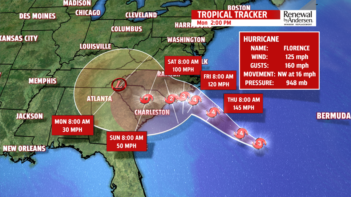
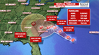
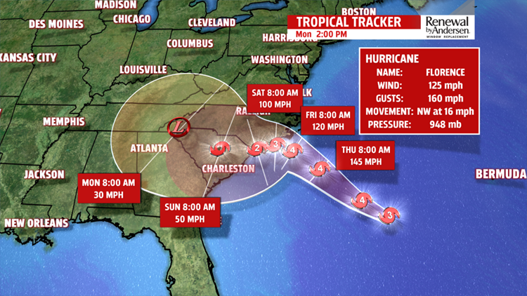
FLORENCE UPDATES: Hurricane Florence has weakened into a Category 3 hurricane as of 3PM Wednesday afternoon. However, it is expected to re-intensify into a Category 4 storm. Landfall is expected early Friday morning. As it nears the coast, the storm slows thanks to a ridge of high pressure to the northwest. As this happens, the storm’s path hobbles along the Carolina Coast and into the southeast, further south than has been anticipated earlier this week.

This means less chance of winds and flooding in our area as a result. Widespread storm surge flooding is expected along the coast with feet of rainfall potentially for North and South Carolina. However, the further south and west the storm pushes, the fewer impacts we see here at home in Central PA. The storm weakens into a run-of-the-mill low pressure system early next week, then migrates in our direction. We could see a few showers as remnants, but nothing nearly as strong as it could have been. Stay tuned for updates on our dreary forecast and for the latest on Hurricane Florence. We’ll keep you Weather Smart!
Have a great one!
-Meteorologist Bradon Long
