


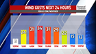
FALL FEEL ARRIVES: Rain showers taper then end late afternoon in the west but linger longer into early evening in the east. Temperatures will fall fast once the front is through. Humidity drops overnight and winds are breezy through the day Friday. Much chillier air and drier air spills in from the northwest. Morning lows are in the upper 40s and lower 50s and afternoon temperatures topping out in the upper 50s

and lower 60s. Skies start mostly sunny then cloud up with colder air aloft helping to produce afternoon clouds. Clouds break up during the evening. Plan on extra layers if heading out Friday evening. Temperatures will be chilly in the 50s then drop to much cooler readings early Saturday. Skies don’t completely clear. Overnight into the early morning hours, a potent shortwave keeps the clouds around and also triggers a few showers.
WEEKEND CHILL: After clouds and a couple of morning showers, high pressure builds in and brings a sunnier afternoon. The breeze is much calmer late in the day. While closer to seasonable averages, the chilliest air of the season arrives early morning with lows bottoming out in the lower and middle 40s. Temperatures barely touch 60 for highs, so many places are in the 50s, despite the bright sunshine. A calm and clear night will lead to even chillier readings near 40 degrees Sunday morning. Plenty of sunshine to begin the day before clouds increase. Highs are in the lower 60s.

NEXT WEEK: Temperatures recover a bit Monday, into the upper 60s, ahead of the next cold front, which brings a chance for showers late in the day and overnight. The wet weather may linger into early Tuesday before drier weather returns. Skies are partly sunny and the breeze picks up too. Temperatures remain in the upper 50s for the day. A more significant trough swings through mid-week, and while It’s dry, temperatures are cooler in the lower and middle 50s for Wednesday and clouds overwhelm the skies. Clouds clear overnight allowing temperatures to dive to the upper 30s Thursday morning. More sunshine is expected and will help to push temperatures near 60 degrees.
The FOX43 Weather Team is keeping you “Weather Smart” 7 days a week!
Have a good day!
MaryEllen Pann,
Chief Meteorologist
