
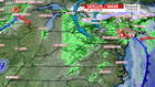

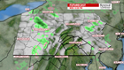

A BREAK IN THE RAIN: The coastal low that has impacted much of our weekend so far will continue to move to the north and provide a break from the rain for much of the day Sunday. Expect a mostly cloudy day on Sunday with a high temperature near 54 degrees. By Sunday evening, another area of low pressure brings a chance for showers though the overnight period and early Monday morning. High pressure then tries to build in from our south on Monday and Tuesday. Monday starts out mostly cloudy with highs in the mid-50s – but look for sunny conditions on Tuesday, feeling more seasonal, with an afternoon high around 58 degrees.
HALLOWEEN: Wednesday looks like one of the warmest days of the week. Southwesterly flow ahead of a system moving out of the Great Lakes and Midwest will bump our temperatures above seasonal normal for this time of year. Look for an afternoon high on Wednesday near 66 degrees an under partly cloudy skies.
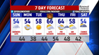

BACK TO THE 50s: Cold front approaches Thursday into Friday and brings with it scattered showers late Thursday and into Friday morning. It also puts temperatures back into the mid-50s for the end of the week.
Enjoy the rest of the weekend!
– Meteorologist Alan Petko
