

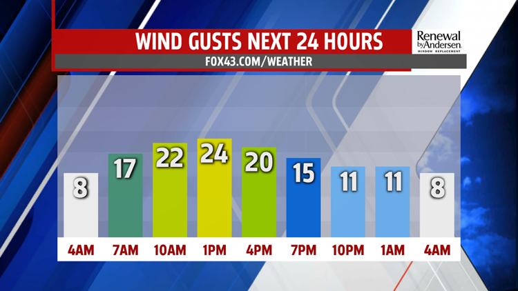

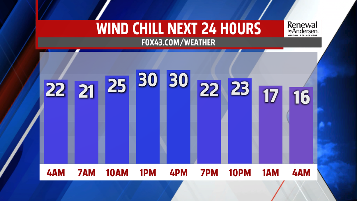
QUIET & MILDER BUT BREEZY: A weak cold front approaching the region brings more clouds to the region Wednesday, in addition to breezy winds. Lows start in the middle to upper 20s. Temperatures continue to climb a little higher on Wednesday. Skies are partly cloudy to mostly sunny. Afternoon temperatures reach the upper 30s to near 40 degrees. It’s a bit breezy, and that makes temperatures feel chillier. Readings feel like the 30s, and even the 20s for some. Skies are partly clear through the night. Temperatures fall into the lower to middle 20s.
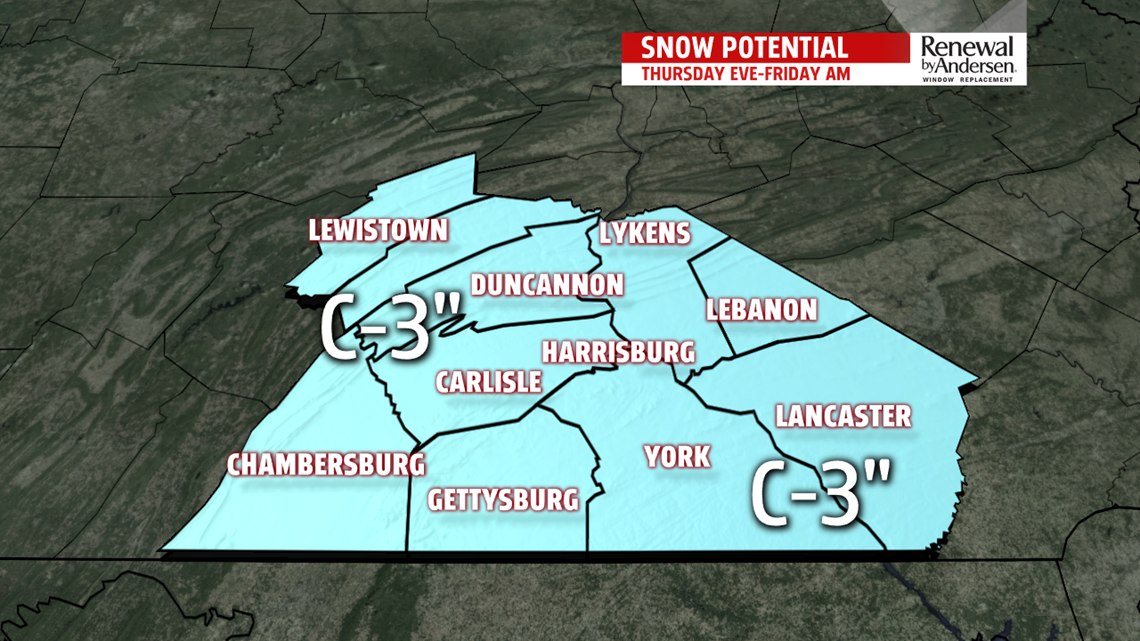
ANOTHER LIGHT SNOW: The end of the week forecast is quiet overall, but another kiss of snow sneaks in Thursday night. In the meantime, Thursday sees mostly cloudy skies. Temperatures reach the upper 20s to lower 30s. Through the night, the weak system passes through Central PA. It brings some snow showers early during the evening, with periods of light snow likely through the night. It’s out of here by daybreak on Friday, with plenty of sunshine to start. Temperatures dip into the upper 20s to near the freezing mark. Clouds increase ahead of what looks to be an even bigger system for the weekend. Temperatures reach the upper 30s to lower 40s.

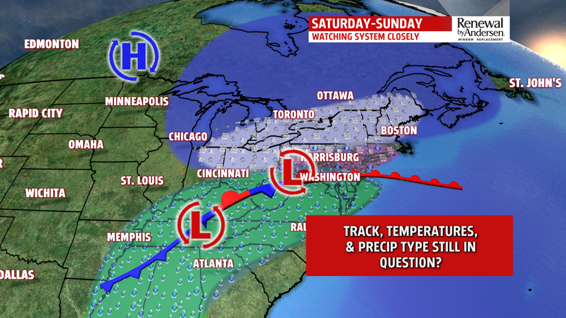
ANOTHER WEEKEND WINTER WEATHER SYSTEM: There’s yet another system we are monitoring for the upcoming weekend. Based on the way models are wobbling with the track, there’s strong indication it brings a wintry mix late Saturday and through Sunday. There’s plenty of uncertainty with track, timing, precipitation type, and amounts/timing of each type to even attempt giving a reliable forecast still at this time. So of course, as is typical with these types of systems so far in advance, it is way too early to tell, and we must wait for time to sort out the differences. Stay tuned over the next couple of days!
ARCTIC BLAST NEXT WEEK: Next week brings the first Arctic blast of air! Monday temperatures begin in the single digits under partly clear skies. Afternoon temperatures only reach the teens to near 20 degrees under partly sunny to mostly cloudy skies. It’s gusty with lake effect flurries. Wind chill values feel like the single digits, even below 0 at times. Tuesday isn’t as brutally cold, but it’s still quite frigid. Temperatures reach the lower to middle 20s after another frigid start in the single digits.
Stay Weather Smart with FOX43! Have a great Wednesday!
