

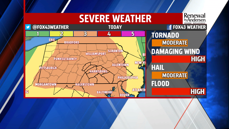


SEVERE WEATHER TODAY: Showers and thunderstorms persist into the early evening. A few of them likely will be severe. Hail, damaging winds and flash flooding are our main concerns, but tornado activity is possible. On a scale of 1-to-5 for severe weather, we’re at a 3 for this afternoon. The main line of any severe activity pushes through the area by dinner, with residual showers and storms into the evening. That second round will be significantly less strong, if they develop at all. Temperatures stay mild overnight after a high today in the low-80s. We dip into the 60s Friday morning under mostly cloudy skies.


HEADING INTO THE HOLIDAY WEEKEND: Breezy conditions dominate Friday with highs in the upper-70s and nera 80-degrees. We look to stay dry under partly cloudy skies. Humidity increases again heading into Saturday, Sunday and Monday. A couple of thunderstorms will be possible each day, but with no heavily organized development currently in the forecast. Don’t change any plans, but be ready to head inside. We have a very low threat for storms to be severe, as of now, for Saturday. Stay tuned for updates. Highs each day creep up into the low-to-mid 80s with lows in the 60s for most.


NEXT WEEK: We keep our warmer temperatures after the holiday. The stray thunderstorm chance Monday goes away by Tuesday. Partly cloudy skies remain with highs near 80. We get a bump up next Wednesday with highs in the mid-80s heading into the middle of the next work week.
Stay “Weather Smart” with the FOX43 Weather Team all week long!
-Chief Meteorologist MaryEllen Pann
