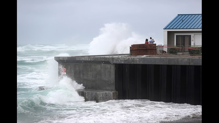
UPDATE: Isaias has strengthened back to a hurricane and slammed into North Carolina, the National Hurricane Center said Monday evening.
The storm -- which now has maximum sustained winds of 85 mph -- struck Ocean Isle beach at 11:10 p.m. as a Category 1 hurricane.
Coastal flooding from storm surge, minor wind damage and inland flooding from heavy rainfall is still likely to occur in the Carolinas on Monday night. The threat of tropical storm-force winds and flooding will continue through the mid-Atlantic and into the Northeast during the day Tuesday.
PREVIOUSLY REPORTED:
Isaias has strengthened back to a hurricane and is accelerating toward landfall near the border between North and South Carolina, the National Hurricane Center said Monday evening.
The storm which now has maximum sustained winds of 75 mph is expected to make landfall as a hurricane around midnight.
The upgrade to a hurricane was expected and the anticipated impacts did not change significantly from what was forecast earlier Monday. Coastal flooding from storm surge, minor wind damage and inland flooding from heavy rainfall is still likely to occur in the Carolinas on Monday night. The threat of tropical storm-force winds and flooding will continue through the mid-Atlantic and into the Northeast during the day Tuesday.
A hurricane warning is in effect from the South Santee River area in South Carolina to Surf City, North Carolina, the NHC said in its 8 p.m. update. A hurricane warning means hurricane conditions are expected somewhere within the warning area.
Storm surge in some parts of the hurricane warning area is expected to reach up to 5 feet.
After landfall, Isaias is forecast to gradually weaken, but the storm is expected to bring strong winds all along the East Coast on Tuesday, including in Washington, DC, Philadelphia and New York. Philadelphia is forecast to see winds of 60-65 mph, while New York will see winds of 65-70 mph.
The storm could bring the strongest winds to New York City since Superstorm Sandy almost eight years ago, Ross Dickman, the meteorologist-in-charge at the NWS office in New York.
"The wind and flooding impacts from Isaias will be similar to what the city has seen from some of the strongest coastal storms," such as nor'easters -- "but we haven't seen one this strong in many years," he said.
Evacuations ordered for coastal communities
In North Carolina, the Outer Banks communities of Ocracoke Island, which took a direct hit from Hurricane Florence in 2018, and Hatteras Island issued mandatory evacuations Friday for all visitors and residents ahead of the anticipated storm that could bring flooding to waterfront and adjacent properties, making roadways in the area unpassable.
Visitors were ordered to evacuate Ocean Isle Beach and Holden Beach by Saturday, officials said.
High winds up to 70 mph are expected and could bring down power lines and trees. Tornadoes are also possible in North and South Carolina, each state's emergency management department said.
A surge warning is in place for Charleston and Colleton counties, including downtown Charleston, which could also see 2-4 feet of ocean water.
Friday, South Carolina Gov. Henry McMaster announced that he would not issue a mandatory evacuation, but that residents should continue to monitor the weather situation.
"Right now we're hoping this storm will not hit us hard if it hits at all," McMaster said. "At this time we have no intention at all of declaring any sort of evacuation."
Charleston Mayor John Tecklenburg encouraged all residents to stay home and off the streets after 6 p.m. Monday.
South Carolina Emergency Management Division (SCEMD) Director Kim Stenson said his department will be implementing its new emergency response plan for a Covid environment which includes screening for the virus, providing personal protective equipment, as well as creating social distancing and isolation areas in shelters.
SCEMD will screen people before they get on buses for transport to shelters and will be having fewer people on buses, requiring more trips, he said.
The shelters are for those who are in homes that may not withstand tropical storm force winds, Stenson added.
Mid-Atlantic and East Coast prep for storm's arrival
A tropical storm warning is in effect for much of the mid-Atlantic and East Coast after it hits the Carolinas late Monday.
A tropical storm warning has been extended northward to Stonington, Maine. A warning south of the Savannah River on the Georgia-South Carolina border has been discontinued.
Storm surge warnings were in effect for Edisto Beach, South Carolina, to Cape Fear, North Carolina; Pamlico and Albemarle sounds in North Carolina, and Oregon Inlet, North Carolina, to the Virginia border.
The mid-Atlantic states should see effects of the storm Tuesday in the Delaware Bay, Tidal Potomac River, Chesapeake Bay and Long Island Sound.
By Wednesday morning, New Hampshire and Maine will see rain as a result of Isaias.
In Maryland, the storm's impending arrival led Gov. Larry Hogan to suspend Covid-19 testing operations at community-based sites for Tuesday.
New York City is implementing interim flood measures in lower Manhattan, including installing temporary barriers to prevent flooding.
Dickman, the NWS meteorologist-in-chief for New York, said winds from Isaias will hit New York from a different direction than from Hurricane Irene or Sandy.
"The track for Isaias is west of the city, which will mean wind direction is from the southeast, south and southwest," Dickman said. "Rarely do we see the strongest winds from this direction. ... Normally, they come from the northeast and northwest."
He said this will likely result in worse damage and power loss from downed trees, as "vulnerable vegetation has not experienced winds like this in a long time."
Utility companies in the area are preparing for the storm and have assured customers that they are ready to respond during the pandemic.
Eversource, a power company that serves Connecticut, Massachusetts and New Hampshire, said in a statement Sunday it is closely monitoring Isaias' path and will have extra crews on hand. The company said it has been working under a Covid-19 pandemic plan since March, and its safety measures would also apply during a major storm response.
Philip O'Brien, spokesman for New York's ConEdison, said his utility is also prepared for Isaias, adding that the tropical storm that passed on July 10 turned out to be a good rehearsal.
"What we are doing now, as of yesterday, is monitoring the storm and preparing for any possible impact in the service area. We are following the path and have different contingencies," O'Brien said.
"One model says it will spin off and weaken, and the other says it could remain a category 1. We are getting designated crew that will go out, which the soonest looks like late Monday or early Tuesday, and determine the appropriate response at that time."


