PENNSYLVANIA, USA — Floods, fires, drought, heat, and thunderstorms all dominated the summer months of 2021.
From the Pacific Northwest to here at home, extreme weather conditions rocked just about everyone across the United States.
Summer seems to always fly by quickly. From baseball games to pool days, weekend barbecues and more, our schedules are jam-packed with as much as we can do to get out and about in Central Pennsylvania.
While we didn't hit 100° at Harrisburg International Airport (the closest we got was 98° back on June 30), it sure felt like it. Heat index values over 100° dominated the summer months with higher than average humidity values topping the scale just about every other week. The average temperature for June and August both were more than three degrees higher than normal (July, just 0.3° above average, but hot). We didn't drop below 60° for morning lows after June 23.
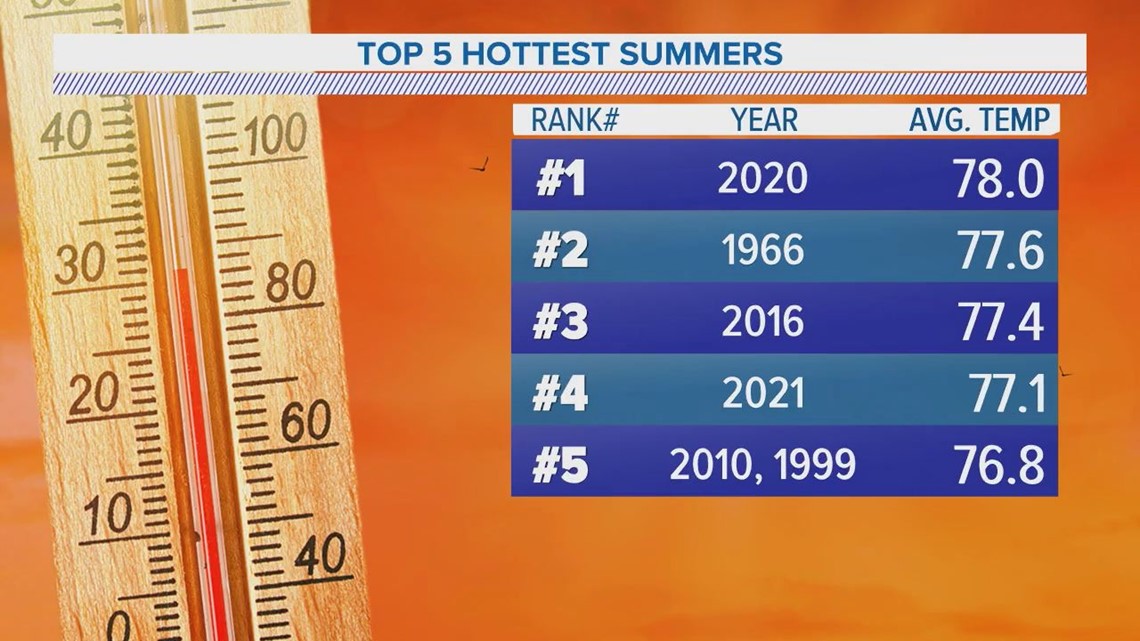
When it comes to the top 5 hottest meteorological summers (June to August) at Harrisburg International Airport, this year ranked in fourth place. The average summer temperature was 77.1°.


But aside from our area, all-time record high temperatures were shattered across the Pacific Northwest. On June 27 and 28, Quillayute, Wash., broke their all-time record by 11°F. More than 200 people died as a result of the heat, according to Climate Central.
Overall, summer 2021 was within the top 10 hottest summers for many across the United States.
But it wasn't just about the heat. In a warming climate like ours, the atmosphere can hold more moisture. This leads to more intense evaporation in some spots with heavier rainfall than others. For the summer of 2021, that meant drought in the west and devastating flooding from the Gulf Coast up into our area. In particular, Tennessee suffered devastating flooding, with up to 17" of rain in some locations in mere hours. More than 20 Tennesseans died in the flooding.
This increased moisture is something that National Weather Service State College meteorologist John Banghoff noted in a conversation with FOX43 as well. When looking at the data, he says there is a definite trend in increased moisture surges for our area over the past decade.
"I think what's interesting here in Pennsylvania is we haven't necessarily been hitting a lot of all-time record highs or all-time record lows necessarily, it's just been sort of on average," Banghoff tells FOX43. "And so we see... that overnight low temperatures are warmer than average, we're seeing that some of these rain events are more productive."
For our area, July came in at 3.26" of rain above average. August, 2.11" of rain above average. The remnants of Tropical Depression Fred drenched us towards the end of the month, and the gut-punch of Ida welcomed the first day of September.
Overall for meteorological summer, it was a top 20 wettest summer on record, coming in at 17th place with 15.99" of rain at Harrisburg International Airport. Record keeping goes back to 1888.
From the wet to the dry, historic wildfires slammed most of the Pacific Northwest as well. Their effect was felt here at home, too, with wildfire smoke both easily seen and smelt across the Mid-Atlantic. Hot, dry, and windy conditions allowed wildfires to spread in July and August, with more than 2.4 million acres burned as of the end of August.
By far scientific consensus, global climate change continues to create more favorable environments for these extreme events to occur. There's even discussion on whether the terms "100-year flood," or "1,000 year heat wave," etc. are outdated, because we are seeing events like this so more frequently within the last decade.
You can find more information on climate change through our Climate Smart series, along with other resources, on our website.
Until next time,
-Chief Meteorologist Bradon Long


