PENNSYLVANIA, USA — Meteorologists are keeping a VERY close eye on the development of a winter system that could bring some snow, or a mix of a snow sleet and rain through the mid-Atlantic and the northeast early next week.
There is a question that remains, and the answer to this question will determine which areas of Central Pennsylvania get snow and how much will fall: Where will this storm track?
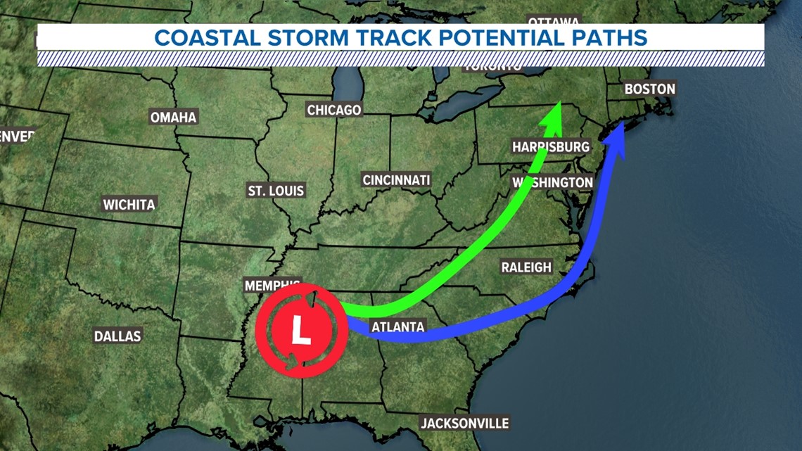
It can sometimes take models a few days to figure out storm track and come into better agreement. The storm that we are looking at is set to bring winter weather to the Southeast before developing into a nor'easter as it moves north up the coast. The exact track of this storm will determine how much snow we get. Here's the two scenarios:


Two Different Scenarios
Lets start out with the fun track, the southern and eastern track that could bring our favorite type of precipitation: SNOW! This path can be seen by checking out the blue arrow. The southern track moves our area of low pressure system eastward, pushing it closer and closer to the coast. This enables cold, moisture rich air to hang around our area starting Sunday evening. In this case, snow is possible later in the evening and continuing through the early hours of Monday morning before transitioning to sleet and rain. As the storm passes, this scenario could bring up to 1-2 inches of snowfall per hour in our northwestern counties. For snow lovers, you're hoping for a favorable track!
Scenario 2 is well…..not as much fun. At all. We are looking at extremely limited amounts of snow, with rain mainly dominating the forecast. It also could have a little bit of sleet mixing with it. This track can be seen by checking out the green arrow. This north and western track brings our low pressure system right over Washington DC, keeping colder air to the west and producing the heaviest snow well to the north and west of us.
Look for the storm to move out rapidly on Monday morning in both scenarios.
So how much snow?
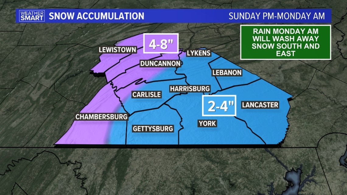
Now that the storm is getting closer, it's time to talk totals. Here's the latest thinking from the Fox43 Weather Team from Sunday evening through late Monday morning.


Our current forecast has the eastern two-thirds of our area receiving 2-4 inches of snow, though areas far southeast such as southern York and Lancaster counties will be on the low end of that total. That's because some sleet and rain are likely to accompany the snow in those areas, which will knock down any accumulations you get. If you're hoping for a big winter storm in York, Lancaster, or Lebanon counties... this storm isn't the one! Our western communities will see a bit more snowfall, with some areas seeing as much as 4-8 inches. Mifflin and Juniata counties will likely see the most snow, with very little mixing expected from this system.
And a friendly disclaimer, if this system shifts west or east, these totals could shift as well! We'll keep you updated as we get more information ahead of the event.
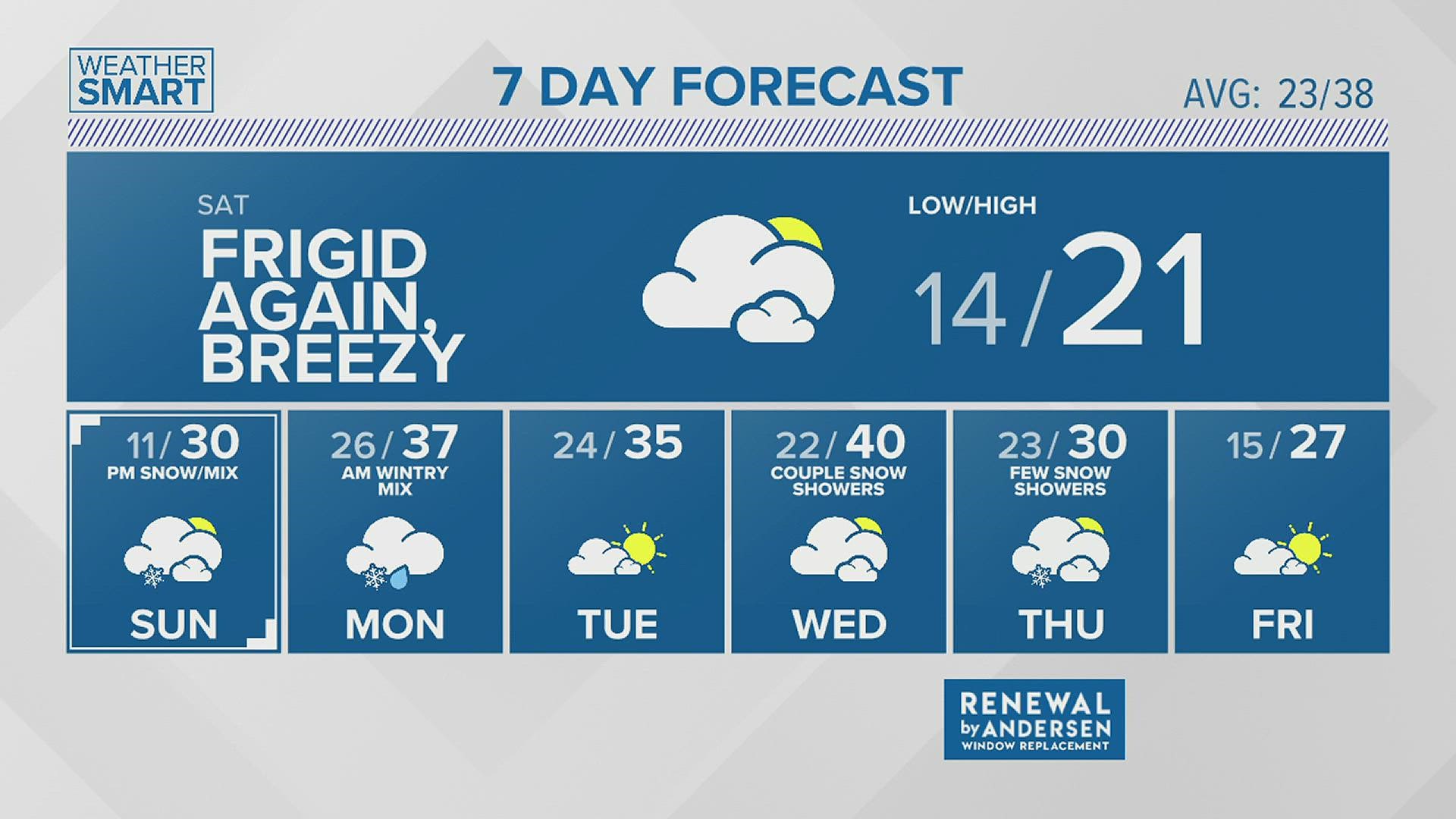
One thing that is a definite with this system is a windy day behind it! As the storm exits, winds will gust as high as 35+ mph on Monday!


Stay with the Fox43 Weather Team for the latest through the weekend!
- Meteorologists Greg Perez and Danielle Miller

