PENNSYLVANIA, USA — It’s Friday, and that means it’s time for another Weather Rewind, where we look back at some of this week’s weather, with a twist.
This week, we look to the not-so-distant past with the winter storm that is finishing up here in central Pennsylvania!
LET’S REWIND
This same system started out in the Rockies on Monday, and it wasn’t too impressive at first.
That changed as the storm started to intensify Tuesday—with blizzard warnings in the Northern Plains to tornado warnings in the Southern Plains!
Severe weather continued along the Gulf states Wednesday, and soaking rains in the Midwest transitioned to an icy, snowier scene across the Great Lakes.
And of course, the storm brought a wintry mix here in central Pennsylvania on Thursday.
But how do some systems bring all snow and others a mix?
WHAT’S HAPPENING?
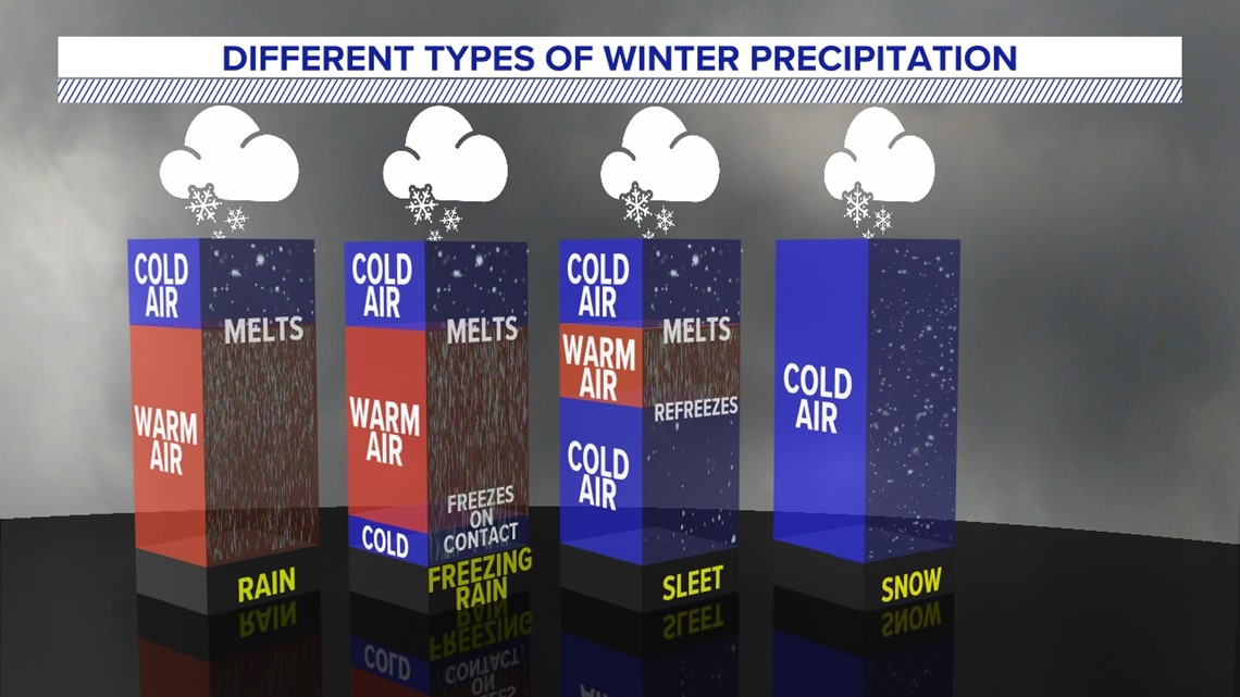
Temperatures are the key here—not just down here at the ground, but also way up into the atmosphere too!
First, keep in mind precipitation in our area starts as all snow way up high in the atmosphere during the colder months.


It’s not necessary for temperatures to be 32 degrees or lower down at the surface, but it must be 32 or lower right above and higher up into the atmosphere to keep it all snow.
If warmer air greater than 32 degrees slips in above the surface, then snow melts, and the precipitation type changes.
If it’s a thin sliver of warmer air, with a deep layer of cold air at the surface, rain refreezes as sleet pellets.
If there’s a thick wedge of warm air immediately above the surface—with temperatures at or below freezing down here at the surface—then rain freezes on contact and creates the sheet of ice we know as freezing rain.
Of course, if there’s a thick layer of warm air above 32 degrees from the surface and well up into the atmosphere, we get plain old rain!
These are the many changes we just saw across our area!
Stay tuned every Friday for the whys behind the weather wonders that catch our eye each week!

